MAPPING: Classifying dynamic processes in arid grasslands
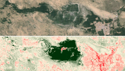
We are living in a time of increasing availability of large scale data from remote sensors, such as Landsat, MODIS and derived products that represent climate and land cover. Ecologists are beginning to take advantage of these data for monitoring habitat change, tracking climate trends, and predicting future biodiversity loss. Classifications of land cover have been useful for documenting forest loss, urbanization and habitat conversion. However, the current global land cover data products are insufficient for arid grasslands for two reasons. First, current classification products have poor performance in arid systems and are extremely unreliable, particularly for distinguishing between cropland and grassland. Second, these classifications are discrete characterizations of dynamic systems and do not provide any information about grassland degradation, or relative condition; rather grassland is classified as a singular static state.
My current research re-imagines the process of grassland mapping, creating a new ontology for classification that incorporates spatio-temporal patterns to intuit land use history and grassland condition, based on known and hypothesized alternate stable state dynamics. You can view slides from a presentation at the 2015 Ecological Society of America meeting on an early stage of this work here.
Proudly powered by Weebly


